The Castlemaine Diggings
The Castlemaine Diggings
National Heritage Park
Mount Alexander gold rush settlements
Evidence of quartz mining
today
Castlemaine Art Gallery and Historical Museum
Great Dividing
Trail Association
The Castlemaine Diggings National Heritage Park
The Castlemaine
Diggings National Heritage Park is situated in a distinctive cultural region
known as central Victoria, in the centre of the Victorian Goldfields region,
123 km north of Melbourne and 38 km south of Bendigo. It extends 50 km from
Castlemaine in the north towards Daylesford in the south, and is up to 10 km
wide. The Park is managed by Parks Victoria.
|
|
|
| Images Courtesy Heritage Victoria | ||


The Park is associated
with the historic gold settlements of Castlemaine, Chewton, Fryerstown,
The Castlemaine Diggings
National Heritage Park is an area of regenerating Box-Ironbark forest and is
associated with the 1850s international gold rush known as Mount Alexander
Rush.
The Park contains
the sources of the gold – sandstone outcrops, quartz reefs, and shallow
alluvial (stream) deposits - that made it one of the world’s richest shallow
goldfields. The goldfield produced over five million ounces of gold, most of it
during the gold rush period, and from the first few metres of soil and rock.
|
|
|
Sandstone Outcrop
|
Quartz Reef
|
Alluvial (stream) Gravels
|


The Castlemaine
Diggings National Heritage Park was
assessed as being of significance to the State of Victoria and added to the
Victorian Heritage Register in 2004 …. The
Park envelops a goldfield which was the catalyst for the Victorian gold rush of
the early 1850s. In that tumultuous decade Victorian gold transformed the
demographic, social, political and economic complexion of
In 2005, the Park
became the 6th place to be added to the Australian National Heritage
List .…The Park is the most outstanding gold rush era site in Australia in
terms of the diversity of types, integrity and time-depth of its collection of
mining sites … Gold and the search for this precious metal, has played a major
role in how our nation has developed. Its influence has left us with the
enduring legacy of exploration, immigration, research, and industrial booms.

Image courtesy of Castlemaine Art Gallery and Historical Museum
Mount Alexander gold rush settlements
The two main
settlements – Chewton and Castlemaine – were created by the Mount Alexander
Rush and they adjoin the Castlemaine Diggings National Heritage Park. Chewton and
Castlemaine are still linked a winding road that was established along Forest
Creek in the first months of the Mount Alexander Gold Rush.
In its shape and
its names, Chewton still wears the feel of a diggings settlement. Chewton’s
streets are not shaped by pomp and bureaucracy, they wriggle and meander.
You’ll find less squatters and gold officials honoured in the streets of
Chewton - hardly any, in fact. Instead, some Chewton streets bear the names of
the gold-bearing gullies and reefs that preceded them - you’ll find Adelaide
and Eureka streets, Dinah and Manchester roads.

Chewton Main Street
Castlemaine became
the centre of government administration when a large colonial government
military camp was established in late 1851. The formal grid of the town was
laid out by the government surveyor in 1852 with reserves for the government
buildings, churches, botanic gardens and a market square that were constructed
over the following decade.
Castlemaine is a
creative person's country town. Wherever
you go in Castlemaine you can see it. Wherever you go, you can feel it. The Market Hall is the most striking
building of the gold rush. Beautifully
restored, it has the symmetry and symbolism of a Grecian temple and looks as if
it was scooped up from the shores of the

Castlemaine in 1857: Image courtesy of Castlemaine Art Gallery and Historical Museum
Mount Alexander Diggings
In 1851 in a
tranquil wooded valley, in a far corner of the world, gold was found. Within a
year, tens of thousands of people flocked to the Mount Alexander area. They
came from all the distance reaches of the earth to the ‘bank till free to all’:
the richest shallow alluvial gold diggings the world would see.
The name
The Diggings is
another name for a goldfield. As one gold seeker observed it: Thousands upon thousands of tents extending
through the gullies for about ten miles in every direction, lots of stores
distinguished by flags, and slaughter houses which might be nosed a mile off,
enough to breed a fever in the place – the ground full of immense holes, many
of them 30 feet deep and the surface cut up by carts and midleg in dust … and
the creek thronged with cradles and tin plans, and fellows washing … [for gold]
… in every direction (Edward Snell)

Image courtesy of Castlemaine Art Gallery and Historical Museum
The legacy today
The historical
data documents the immense scale of human occupation and activity … their efforts left a landscape that littered with depression
and mounds.
To some the
diggings had the appearance of a graveyard¾It
was a sight! Mounds of earth lying beside holes presented the dismal appearance
of a graveyard, men washing dirt in tubs, carrying its colour on their skin,
hair, hats, trousers and boots, miserable-looking low tents their places of
refuge. Where water was to be seen it was puddle. The whole scene to a new chum
was one of unspeakable squalor, surpassing all that his eye had seen or his
fancy woven. (James
Robertson, in Records of Castlemaine
Pioneers, p. 47, Forest Creek, late 1852).

Shallow shafts dug by gold rush miners
Alluvial Gold
Alluvial gold is
gold removed from its parent rock by erosion and incorporated into stream
gravels. Alluvial mining is therefore the extraction of gold from silt, sand,
clay, and gravel deposits. The first alluvial mining
method employed in the Mount Alexander Rush was shallow digging. The
historical data documents the immense scale of human occupation and activity
and provides interpretations for the extant evidence, e.g., such as the
following snippets:
The washdirt often
had to be transported to water sources - besides
the enormous mass of persons stationary at the cradles, there is a moving
population, from the various holes to the cradles on the water side, equally
numerous. Some carry the earth on hand-barrows, made of two long wooden handles
and a sack sewed long wise, on which they carry it. Some use wheel-barrows;
others a piece of bark as a sledge, on which they place a bag full of earth,
and draw it along the ground. Some carry it in sacks on their back, while the
tin dish washers, of which there are hundreds, carry it in their tin dishes on
their heads. (Argus, 27/10/51)

Image courtesy of Castlemaine Art Gallery and Historical Museum
Shafts
Each
digger was allowed a claim of 8ft x 8ft (later increased to 12ft x 12ft) in
which he could dig a shaft and pile excavated earth and rocks.
Inexperienced
miners dug holes that became progressively narrower, like funnels; shapes also
varied - The shafts for the first few
months of the rush were round, and it can be imagined that those sunk by
professional men, Cockneys, etc., were not likely to meet with the approval of
the experienced miner. When the Cornishmen arrived on the field in 1852, they
started the oblong shafts, and very soon their example was generally followed. (McKillop)
The entrances of
shafts was also shaped to keep out the rain - Very unpleasant working in rain or soon after, as every place round is
clay, and the rope, bucket, pick and spade handles, your feet and hands, in
fact all is clay. Majority of holes closed in by logs and clay, except a small
hole in the centre which is generally covered with a sheet of bark. (Finlay,
p. 22)
Haulage devices
depended on the depth of the shaft - In a shallow shaft (less than about 16-18
ft) earth was pulled up by bucket and rope. Deeper than that, diggers used a
pulley set between three sticks arranged in triangle, or a wooden windlass cut
and turned in a couple of hours with an axe. (Fauchery)

Sketch by Robert Kaufman: Digging a shaft
Washing the Gold
The tin dish was the basic tool of every gold digger - Many
of the poorer classes of diggers at first commence operations with a common
tin-dish, and after a few trials seldom fail to acquire a peculiar knack of so
turning the wrist and hand, that every twist sends from the edge of the dish a
portion of water, earth and sand, the whole of the heavier matter drawing
towards the centre. (Earp, p. 124)
Gold diggers supplemented the tin dish with a tub for
soaking (or puddling) a load of washdirt. Tubs for puddling could be half a beer or brandy
barrel, or a hollowed out log - put
contents of four or five buckets of washdirt in tub (half beer barrel or brandy
cask)—then fill it to brim and turn earth over and over with a spade - first
lot of water, reduced to mud, is thrown away and replaced three or four times
until only stones and gravel remain in bottom of tub—separate further with huge
strainer or sieve—then empty fine residue into large tin dish, then wash at
pool or creek. (Fauchery).
The heavy-weight processing tool of the gold digger
was the cradle - The man who works the cradle does so with
his left hand, and, to save stooping, has a handle to it breast high, and in his
right uses a short round stick like a porridge spurtle in stirring the contents
of the sieve, and then in breaking the harder lumps. The ladler again uses for
his purpose a sugar scoop or small tin fastened to a pole, which saves him
wetting his feet. (Matthew Hervey, letter in Argus, 6/10/51)

Sketch by Robert Kaufman: Digging a shaft
Sluicing
Sluicing involved
the use of running water to break down gold-bearing earth, and a sluice box was
used to recover the gold. It involved washing alluvial material through a
channel with riffles (a set of bars or slats) in its base for the capture of a
heavy mineral released from its surrounding material.
Sluice mining had
its drawbacks, particularly floods and droughts - The River Loddon at this season, in former years, was a formidable stream,
often sweeping long-toms, sluices, and other mining apparatus before it; at
present, however, portions of the river bed are being worked with perfect
safety. This state of things is
serviceable to the river workers, but unless we have, during the later months
of spring, a copious rainfall, the consequences will be alarming in the extreme [10, March 1866]
|
|
Sketch by Robert Kaufman: Using a sluice box
|
Surviving evidence of the operation of a sluice box
|


Stream diversions
An adjunct to this
form of sluicing was the construction by miners of diversions was to gain drain
to gullies, creek or river beds, and to provide a water supply to their
sluice. Often, diversions were made
through channels dug alongside the gully, creek or river, and occasionally,
where rivers ran in large loops around rocky spurs, tunnels and cuttings were
used. Few historical accounts have been found dealing with diversions.
An early account
deals with a mining tragedy - At Vaughan (or ‘The Junction, junction of Fryer’s
Creek and the Loddon), late in 1852, three
young Canadian brothers were smothered by the caving in of a cutting, intended
as a drain from the last deep hole on Fryer’s Creek to the Loddon River. Their
father, looking on, was the only one of the party to survive. The locality was
thereafter known as Canadian Point. (G. Duncan, p. 4)
|
|
Sketch by Robert Kaufman: examples of diverting stream through tunnel
|
Surviving evidence of stream diversion by a cutting
|


Cement mining
With all the easy ground
taken up, latecomers to the rush commenced mining a new type of ore deposit,
called cemented gravels. As a creek or river develops from a stream to
maturity, the water cuts its way deeper through the earth’s sediments, leaving
behind a ‘staircase’ of abandoned banks called high terraces. The constant
cycle of erosion often leave the ancient gravels exposed as low hills alongside
the major creeks.
Gold diggers found
the ancient deposits rich in gold but quite different to mine than the creek
flats and gullies - it is dreadful work
to sink in some of the hills, which can be effected only by gads and hammers,
and the driving of three inches is generally a good day's work for a couple of
good able miners; whereas they could easily sink six feet per diem in the
gullies. [83: 8/3/1852: p.2].
|
|


Puddling machines
These
horse-powered machines could process a couple of tons of earth and were
introduced to enable the alluvial (or free gold) gold to be separated economically.
A puddling mill consisted of an annular timber-lined trough with centre bearing
and a revolving horizontal timber pole with a trailing harrow like implement to
break the clayey gravels into a slurry and drawn around by a horse following a
circular path. Water was provided via a race and the slurry was taken of via a
tail-race.
Puddling machines
- The ground has been turned over and
over again, and now the whole of the alluvium found in the gullies is being put
through the puddling machines, and excellent wages is the result. There is no doubt but the present process
will be continued until the whole of the known auriferous gullies will be
entirely washed away in the shape of sludge, leaving nothing behind but the
bare bed rock and sundry heaps of stones to show where the gold has been taken
from. [December 1861:10]
|
|
Sketch by Robert Kaufman: Puddling machine
|
Surviving evidence of a puddling machine |


Ground sluicing
A
ground sluice is a constructed or excavated channel through which flows controlled
amounts of water. The sluice included an inlet (head race); sections which
contained timber sluice boxes for collecting the gold by means of various
configurations of riffles and mats to trap the heavier particles while allowing
the waste to continue through; and a main drain (or tail race) to dispose of
large volumes of soil downstream.
The
water was delivered via a race to spurs above the selected mining areas and
then directed downwards through the auriferous gravels, concentrating the gold (in
the sluice boxes) and bearing off the lighter material down the tail race.
Ground sluicing left behind high remnant faces and large pits with pebble heaps
on bedrock through which run networks of channels connecting to the tail race.
|
|


Quartz Mining
Quartz mining
dates back the discovery of the field - The first gold discovery of Mt Alexander was made by John Worley and
Christopher Thomas Peters at Specimen Gully on the 20th July, 1851 … the first dish of stuff was … obtained from a
little gully, and panned off in a small soup tin, the result being half-a-dozen
pieces of gold about the size of "wheat corns" … The next attempt was
in the hill side - about 100 yards from the first gold - into which they drove
a tunnel and discovered a quartz leader, thickly impregnated with gold. This necessitated the breaking up of the
quartz, which they considered too much trouble, and soon left it. [39: p. 15]
In 1852, a small
number of Mt Alexander diggers, not content with merely sinking into those 'six
feet of the surface', first turned their attention to the gold to be found in
quartz. The aptly named Quartz Hill was
the first reef to be tried, when¾6 to 8 inches of its eastern face was broken off,
roasted, and crushed with hand-hammers, yielding, with these primitive
appliances, from 60 to 72 oz. to the foot super... [10: Dec 1886]
|
|


Mining
At first the
miners open cut, working only the surface shows of quartz, but to work at any
depth they had to sink shafts or drive tunnels. Most miners were able to
profitably work their ground with hand or horse-powered machinery—haulage whims
and whips—down to the water-level.
|
|
|
Sketch by Robert Kaufman: mining a reef from the surface
|


Machinery
Mining below the water
level required steam-powered pumping and winding machinery, the cost of which
usually led to the development of large company mining.
|
|


Evidence of quartz mining today
The evidence of past quartz reefing is probably the
most extensive and best preserved of all mining types. Relics survive from all mining periods and
types of operations and include such things as surface workings, mullock heaps,
shafts, poppet heads, whip and whim foundations, machinery foundations, and
abandoned plant, buildings, tracks and tramways, water dams and slum ponds..
|
|
1860s mullock heap
|
1930s mullock heap
|


Roasting ore
A necessary
preliminary to early quartz crushing was the roasting of the rock in a kiln. Roasting
‘softened’ the quartz, making it brittle and easier to crush. Quartz roasting kilns can be similar in shape
and construction to lime kilns, but have been found in
Pioneering quartz
mining companies roasted the quartz ore in kilns as a prelude to grinding or
crushing¾ At Old Post Office Hill is a machine in full
play, and it may be regarded as a very fair specimen of such works as can be
accomplished by the united exertions and money of five or six spirited
diggers. After being roasted in
quantities of about thirty tons, laid alternately in layers of wood and burnt
(sometimes for a week), until the crushing is rendered a much easier process [47:
30 Nov 1855, p.2]
|
|


Crushing ore
The quartz had to crushed to a fine sand to
extract the gold – methods ranged from the primitive hand dolly to large, highly
capitalised, crushing and treatment plants. Early crushing mills (Berdan pans
and Chilian mills) and stamping batteries were in some cases driven by horses
initially; more commonly, though, steam-engines or waterwheels powered them.
Batteries with revolving stampers were to become almost universally used in
|
|


Cornish mining technology ─ Uphill flues or chimneys
Blight and party, who have united with Stewart and
Robbins, have their mill now in fine working order, and have been doing good
execution of late. In the clearing away old stacks of quartz, the richest
having been previously crushed, the yield has been from two to nine ounces to
the ton. The yield of their famous rich stack, we never could get at, and our impression is,
that it did not fulfill their expectation. The gold was in the seams or
facings, where the stone broke, and consequently the glitter was all on the
outside. That it yielded well, however, there is no doubt. This party’s mill is
worthy of more than a passing notice. The engine is a horizontal lever of
twelve horse-power, and with the draught obtained by a flue of eighty-eight
feet (advantage being taken of the hill, to save expense in erecting a
chimney), it works up to its full capacity. There are 8 stamps, which are
rather light, but heavier ones are about to be ordered.
|
|


Continuing mining
In 1870 a boom in quartz
mining investment resulted in an unprecedented number of public mining
companies in operation, and transformed the goldfield's flagging fortunes. One of the reasons was the injection of
capital from outside the district - Numbers
of gentlemen experienced and interested in mining in other gold-fields have
visited Castlemaine, and show their belief in its auriferous resources by
investing their capital.
Another positive
influence was the support for the strategy of deep sinking. By the end of 1873
four mines in the Castlemaine Division were at depths of more than 300
feet - the Ajax at 400ft, the Sebastopol
at 413ft, the Eureka at 360ft, and the Old Wattle Gully at 339ft. Deep sinking
resulted in an influx of new machinery and soon the field boasted twenty-four
steam engines at work driving pumping machinery to drain mines on seventeen
reefs - The Eureka Consols have 40 men
employed; they have fixed pump plunger, &c., in their engine-shaft, and are
sinking it from 280 to 400 feet, driving cross-cuts to eastern and western
reefs, sinking winze and works for ventilation; and from the main body,
sometimes 14 feet thick, they have crushed about 1200 tons, averaging 3½ dwts to the ton. [10, Dec 1871]
|
|


Cyaniding
In the late 1890s a
new ore processing technique commenced being used in Victoria. Although
cyaniding was already well-established overseas, particularly in South Africa,
its introduction to Victoria had been delayed by patent restrictions, which,
along with an attendant heavy royalty, were abolished in February 1896, making
the treatment of low-grade tailings in Australia feasible.
The cyanide
process was not initially widely adopted in
|
|


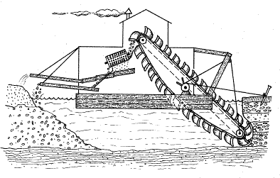
Pump sluicing and dredging
At the turn of the
twentieth century new developments in hydraulic sluicing began to revive the
fortunes of alluvial mining.
Leading the way
was the appearance of bucket dredges in 1898. The first dredge worked at along
a section of Campbells Creek - Campbell's
Creek Dredging Co.: 27,720 tons, for 414 oz gold [10, March 1899]
Ray Bradfield, a
local historian, provided this description of one of the early dredges - The dredge was powered by a pair of compound
steam engines, 16 hp. Her boiler was 22
feet long, and 8 feet in diameter, her pumps operated a nozzle jet at 45 lbs
per square inch pressure, and put through 7,000 gallons per minute. Her buckets held four and a half cubic yards,
and 11 of these were discharged in each minute, under ordinary conditions.
...Over the three years, 1907-8-9, she treated 223,
|
|

Jet elevator sluicing
Another innovation
in this period was hydraulic sluicing or jet elevator sluicing. A.J. Cox, arriving from Beechworth
around the turn of the century, is credited with introducing to the district
the Jet Elevator system of hydraulic sluicing, with outstanding success. The sluicing business quickly expended in the
following years and in 1905 it was estimated that 18 dredging/sluicing plants
were operating along
|
|


What is there to see?
There are many
relics and traces of gold-mining, ruins of gold-rush settlement throughout
towns like Castlemaine and Chewton which still bear, in the buildings and
streetscapes, the heritage and magic of their golden past.
The surrounding Box-Ironbark
forest has its own secrets. Its natural attributes—bush life, topography and
geology— coexist with historic gold rush mining relics and evidence of
Aboriginal occupation to form an extraordinary, layered landscape.
|
|
Castlemaine Streetscape
|


Getting about
Finding your way – There is a Visitor Information Centre at Castlemaine
that can help you with information about the trail, tour guides, accommodation,
special facilities, maps and any other queries.
Getting a bed - You won’t have to sleep under a wagon any more. You
can put your feet up in a luxury bed and breakfast establishment, drop into a
convenient motel (from the luxurious to quite comfortable) or, if you decide on
a cabin or camp in one of the caravan parks, you are still way ahead of 1850s
accommodation.
Getting fed - It is easy to find excellent coffee shops, cafés and
restaurants throughout the region—try a different one every day. There are also
many great places to enjoy a picnic lunch.
Tracks and trails - Some roads are unsealed, and may sometimes be a bit
dusty, muddy or bumpy. If you are not accustomed to unsealed roads, remember to
drive slowly, particularly on corners. The walking tracks are OK for a person
of average fitness, but you will need a strong pair of walking shoes for all
but the shortest of strolls. Smooth rides, suitable for wheel chairs are
indicated at the top of site pages.
Out in the weather - It can be cold and wet at times in autumn, winter and
spring, so rug up and bring something waterproof. In the warmer months it can
get quite hot. Wear a sun hat, use sun block and carry
Castlemaine
Diggings National Heritage Park is inspirational as a forest that has remade
itself around the relics that the gold-diggers left behind. The park and its
associated gold towns are also genealogical 'hot spots' for Australians and
overseas visitors. As Robyn Annear writes in her preface to Nothing But Gold¾ ‘There
are perhaps hundreds of thousands of Australians like me, with ancestors who
were part of the rush to the goldfields of

Image: Courtesy of Castlemaine Art Gallery and Historical Museum
Further information
Castlemaine Visitor Information
Centre
Located in the historic Market Building,
Mostyn St, Castlemaine

The Visitor
Information Centre is open every day (except Christmas Day) and provides
visitors with many forms of information about the Diggings, including video
clips, books, maps and photographs. They
also provide an Accommodation Booking Service (1800 171 888), bicycle hire and
portable MP3 players with guided audio tours of the town and the Diggings
Sites.
Online
·
www.maldoncastlemaine.com.au – podcast tours: Diggings Tour,
Castlemaine Town Tour and Eureka Reef Walk and short films
·
www.goldfieldstrack.com.au – The Goldfields Track is a journey
through time.
·
www.gdt.org.au – Great Dividing Trail Association
·
Heritage
Victoria –
iPhone/iPad App is available from the Apple iTunes Store giving the location
and descriptions of all places listed on the Victorian Heritage Register,
including the Castlemaine Diggings National Heritage Park and individually
listed places within the park
Mount
Alexander Pod Tours - downloadable from Mount Alexander Shire
Council’s tourism website at www.maldoncastlemaine.com.au
GOLD RUSH TO
Narrator
– Jan ‘Yarn’ Wositzky and interviews with Robyn Annear and Dennis O’Hoy.
Three
linked heritage tours through the
• THE
RUSH – you will hear about the gold rush proper, and visit the places where it
all happened.
• THE
CHARACTERS – here you’ll travel to the ghost towns beyond the main rush and
meet the people who were there, the men and women, the civilized and otherwise.
• NEW
GOLD MOUNTAIN – you will be introduced to the stories of the indigenous Jarra
people, where geology meets the Dreamtime, and also bring you the wonderful
tale of the Chinese who came to this place they called New Gold Mountain.
Narrator
– Jan ‘Yarn’ Wositzky and interviews with Jaara Elder Brien Nelson.
Today
the Eureka Reef is a quiet place. The only sounds, apart from the comings and
goings of us people, are the calls of birds and the wind in the trees. But in
1857 it was
a busy
and noisy gold mining centre, filled with the noise of the thumping of
batteries crushing quartz rock and trolleys trundling along railway lines, of
horses pulling carts and people digging, building dams and stone walls and
huts, and the cries of children and dogs. What these people left behind are
like pieces of Braille, scattered across the land, and it’s from these
fragments that we are going to imagine and tell the story of this place, the
Eureka Reef, and of the people who were here.
CASTLEMAINE TOWN
TOUR
Narrator
– Jan ‘Yarn’ Wositzky and interviews with Felix Cappy, Robyn Annear, Brian
McCormick, Ben Laycock and Ken Parker.
Castlemaine
is the creative person’s country town, rich in the cultural heritage of the
Victorian Gold Rush. Wherever you go in Castlemaine you can see it. Wherever
you go, you can feel it – in the art galleries, the Botanical Gardens, the
Mount
Alexander Short Films - downloadable
from Mount Alexander Shire Council’s tourism website at www.maldoncastlemaine.com.au
Narrators
– Gerry Gill and Felix Cappy
INTRODUCTION
TO JAARA COUNTRY
Narrators
– Jaara Elder Brien Nelson and Gerry Gill
Prior
to the gold rush, there were many Aboriginal clans in central
THE
GOLD RUSH TO
Narrator
– David Bannear
The film
illustrates the history of the gold rush through its surviving evidence
preserved in the
CELEBRATIONS
IN THE GOLDFIELDS
Narrator
– Elissa O’Connor
This
film presents a range of community based events that take place in and around
VIBRANT
ARTS
Narrator
– Jodie J. Hill
This
film showcases the region’s concentration of artistic talent.
MALDON
FOLK FESTIVAL
Narrator
– Lynda Bullen
Maldon’s
folk festival has been going over 30 years. It still remains true to its
founding principles of supporting Maldon’s tourism focus as
Castlemaine Art Gallery and
Historical Museum
Founded
in 1913, the Castlemaine Art Gallery and Historical Museum has acquired an
excellent collection of Australian art works and of historical items from the
district’s past.
The
1931 art deco building is noted for its elegant design and is Heritage listed.
The building has been extended a number of times. The Gallery and Museum is
fully accredited by Museums Australia.
The
Museum
Drawing
on the
The
Gallery
The
Gallery has always specialised in Australian art. Its particular strength is in major works of
the late 1800s, the Golden Period of Australian painting, and the Edwardian
era. Traditional landscape painting is a feature of the collection. More
contemporary artists are also well represented.
Great Dividing Trail
Association
The
Great Dividing Trail, a community-planned long distance trail that allows
recreational walkers and tourists the time to savour central Victoria's unique combination
of gold rush heritage and its natural beauty. All major entry points are accessible by public
transport as well as by road from smaller centres, with the possibility of
overnight Accommodation and camping.
Created
by a community-owned organisation, the Great Dividing Trail Association (GDTA),
the Trail links the old gold rush towns at the heart of Victoria, as well as
the forests, hills and lakes, straddling the Australian Great Dividing Range.
The main, north-south 'spine' of the GDT (connecting the Goldfields towns of
Buninyong, Ballarat, Creswick, Daylesford, Castlemaine & Bendigo) is now
promoted as the Goldfields
Track and has been adapted to allow use by mountain bikes
The Great Dividing Trail (GDT) Network currently includes:
·
Goldfields Track containing three sections - Dry
Diggings, Wallaby
(incorporating former Federation Track) and Leanganook Tracks).
·
Lerderderg Track
The GDTA sells
maps for the Lerderderg Track and the three tracks that comprise the Goldfields
Track via its website, www.gdt.org.au, using PayPal.
Information
Victoria also sells the maps (80 Collins St Melb,1300 366 356) as do several
regional visitor information centres.
·
Ballarat:
www.visitballarat.com.au 1800 446 663
·
·
Castlemaine:
www.maldoncastlemaine.com.au 1800 171 888
·
Creswick:
www.visitcreswick.com 03 5345 1114
·
Daylesford:
www.visitdaylesford.com 03 5321 6123
You can walk or ride the
Goldfields Track
|
|


Heritage Victoria
Heritage Victoria
now has a free App for iPhone/iPad that helps you explore the architectural and
historical gems of Melbourne and regional Victoria, providing access to the
Victorian Heritage database while on-the-go. It features audio walking tours,
allows users to create their own tours, and to add their own stories and images
to the official records of heritage places. The App is the perfect companion
for visitors or locals with an interest in architecture and design, history and
heritage
The whole of the
Castlemaine Diggings National Heritage Park is one of the places featured on
Vic-Heritage app along with around twenty individually listed places locate in
the park. The red highlighted places form part
of the Diggings Trail
Castlemaine Diggings National Heritage Park H2407
Individually
listed places within the park
Cemetery Reef
Gully Cemetery H1412
Cobblers
Cobblers Gully
Quartz Roasting Kiln H1277
Deadmans Gully
Burial Ground H1750
Deadmans Gully
Cemetery H1410
Forest
Creek Tourist Gold Mine H1322
Herons
Reef Historic Gold Diggings H1323
Pennyweight
Flat Cemetery H1675
Red Hill
Hydraulic Gold Sluicing Site H1230
Duke of
Cornwall Engine House H0385 (private property, no access)
Sailors Gully Gold
Mining Precinct H1239
Specimen Gully
Gold Memorial H1242
Specimen Gully
Quartz Mining Association Gold Mine H1235
Spring
Gully Quartz Mines H1234
Spring Gully Gold
Puddling Site H1245
Wattle
Gully Gold Mine H1879